Task Description
Patients were told to imagine themselves walking around in a fictional town pictured on the computer screen. The goal was to find particular locations in the town that were marked on a map as buildings A through H. During the task, patients were not allowed to change the direction of the map or the town (computer screen) to adjust their orientation. According to the mechanisms of alignment effect, patients had to imagine that they were actually walking around the town while holding the map. They were able to align themselves with the direction of the map and the imagined town only by shifting their viewpoints to different places around the town. Two different kinds of response time were calculated as main measures.
Materials
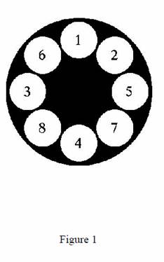
A laptop computer with 12.1-inch LCD touch panel was set up on a table facing the patient. The patient, when seated, looked down at the center of the monitor at a 45-degree angle. As shown in Figure 1, a black circle with a diameter of 18.5 cm was drawn on a white background on the monitor, which itself had a black outer frame. Around the periphery of the black circle, eight white circles 5-cm in diameter were drawn at even intervals, with each of the central angles equal to 45 degrees. The numerals from 1-8 were pasted on the circles in the task trials. A Windows-based program developed for this project regulated the presentation of the stimuli and the measurement of response time, based on touch input from the panel. Response time was measured in 0.001 s units and recorded in the computer along with information such as stimulus presentation conditions and responses. A beep signaling the presentation of the stimulus was emitted from a speaker in the computer
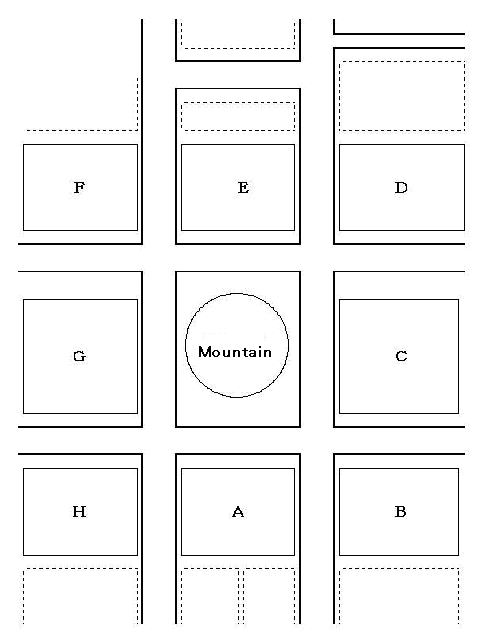
Figure 2
Procedure
The task was conducted with each patient individually. The patient was given a map of a town (Figure 2) in which eight buildings named A to H surrounded a circular mountain. They were told that the eight circles on the computer represented a miniature town and that the map they were holding was a map of that town. Each trial consisted of the following four steps. (1) The tester verbally stated one letter from A to H, which represented a particular building on the map, referred to as the ‘destination’. (2) One second after the patient verified this position on the map, a beep, the signal for stimulus presentation, was sounded for 1 second. (3) Following one second delay, one of the eight white circles turned red, with that circle representing the ‘present location’. (4) The patient responded by pushing the number on the screen that would correspond to the destination when the present location and Building A on the map coincided. The time taken from the white circle turning red, signaling the present location, to the patients’ response was automatically recorded.
